
Underwater navigation for submarines
by Robert Derencin
1. Introduction
Navigation is the method of guiding a ship (or a submarine) from one place to another by the most safe and efficient way. The first task of the navigation is to know a ship's (or a submarine's) position at any time. Depending on region of navigation, the navigation is divided into coastal, oceanic (open-sea) and polar navigation. Depending on navigational system, there are terrestrial navigation, astronomical navigation, electronic navigation and dead reckoning navigation. In the case of a submarine navigation there are surface and underwater navigation. In this article will be explained just some navigation systems which can be used when a submarine is submerged (on periscope depth and deeper).2. A submarine compass and lines of position
2.1. A submarine compass
A ship (a submarine) course is angle between currently direction of navigation and a meridian. The course is controlled by means of compass. From the first days of submarines, there were two kinds of compasses. The very first submarine compasses were magnetic compasses. On the British Royal Navy submarines of Type A (1903) the magnetic compass was located out of the submarine hull, on the submarines' command bridge. The compass was closed inside impermeable stand. Inside the submarine it was possible to keep the submarine's course by means of telescope. The compass and the telescope were improved by the time, but one problem remains. Classic magnetic compasses were not able for navigation on submarines because of the submarines' magnetic shell effect. Because of that, the magnetic compasses' deviations were too big.The German Hermann Anschutz-Kaempfe designed a gyro-compass equipped with one spinning top (gyroscope) in 1907 (1908). In 1912 he designed gyro-compass equipped with three spinning tops. The new gyro-compass was better for use on rough sea. In 1925 started production of improved gyro-compass (equipped with two spinning tops). Elmer Sperry (USA) patented his type of gyro compass (with one spinning top) in 1911. Also, Sidney Brown (UK) patented his type of gyro-compass in 1916.
A gyro-compass' gyroscope, under influence of the Earth's revolution and gravitation, try to keep its axis parallel with the Earth's axis. On this way, the gyro-compass shows direction of true meridian (i.e. true North). The gyro-compass is insensible from magnetic effects of a submarine or from the Earth's magnetism.
The biggest influence on a gyro-compass is change of geographical latitude. With the increasing of the latitude angle between the gyroscope axis and the Earth axis is bigger and the compass' direction force is weaker. The gyro-compass is useful up to latitude of 70 degrees North and South. Between 70 to 85 degrees North and South the compass is useful with correction of "latitude error" by means of special tables. Above latitude of 85 degrees North and South normally constructed gyro-compass is not useful.
The gyro-compass errors are geographical latitude error, sailing (navigation) error, a submarine acceleration error, a submarine rolling and vibrating error and the compass installation error.
AC (Alternating Current) electric current powers a gyro compass. The current frequency is (for example) 210 Hz, 333 Hz or (these days) 400 Hz. The current can be produced by motor-generator, but these days a semiconductor-converter is used. Because of safety, there must be reserve power-supply.
After starting of a gyro-compass, a gyroscope must to get required speed of its rotation. After the gyroscope gets the required speed it is stabilised in direction of true meridian. Because of that, a gyro-compass must be started from 1 to 4 hours before navigation.
2.2. Lines of position
A submarine position is determined by crossing of (at least) two lines of position. The line of position can be:- a straight line (azimuth which is getting by visual directing of some coastal object or directing by radio-direction finder),
- a circle (distance of some object which is getting by measuring of horizontal or vertical angle, for example)
- a curve (isobaric which is getting by measuring of sea depth)
- a hyperbola ( in hyperbolic navigation systems, Omega navigation system, for example)
3. Terrestrial navigation
In terrestrial navigation a submarine position is fixed by direct visual observing of characteristic natural or artificial coastal objects and/or by measuring of sea depths. Position determined on that way is called "fix" or "observed fix". The characteristic objects are lighthouses, trigonometric points, church-towers, towers, chimneys, buildings, mountain peaks etc.The observing can be done simultaneously or in time intervals. Position determined by simultaneously observing is more correct. If a submarine speed is up to 10 knots, the simultaneously observing must be done within time period of 1 minute. If a submarine speed is from 10 to 20 knots, the time period is within half of minute, etc.
The terrestrial navigation is used when a submarine navigates in coastal waters. Primarily, the terrestrial navigation is intended for surface navigation. But, when a submarine dives to periscope depth, the submarine is able to fix her position by means of the terrestrial navigation, too. It is more difficult, especially during rough sea, rain and overcast. Observing range is limited because of low altitude of the periscope. But, it is possible to fix the submarine position.
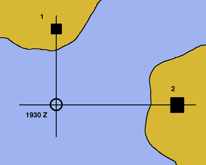
Picture 1
Picture 1 shows situation in which a submarine fixes her position by means of observing of two coastal objects. Azimuth of the first object is 0 (zero) degrees and azimuth of the second object is 90 degrees (from the submarine). Because positions of the objects are known (the object are drawn in navigational chart) and the submarine position is not known, both azimuths must be summed-up with 180 degrees.
1st azimuth: 0 degrees + 180 degrees = 180 degrees
2nd azimuth: 90 degrees + 180 degrees = 270 degrees
Then, two lines of position must be drawn on the navigational chart. The first line of position azimuth is 180 degrees from the first object. Second line of position azimuth is 270 degrees from the second object. Intersection of the two lines of position is the submarine position. In this case, both lines of position are straight lines. Beside the position must be registered time of the last observing. For example, if the second object was observed lately than the first object, time of the second object observing must be written (in this example- 1930 Z).
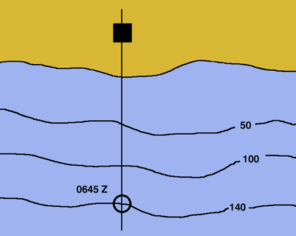
Picture 2
Picture 2 shows situation when a submarine navigates towards a coast and on the coast is just one object (drawn on navigational chart). But, on the chart are also drawn sea depths (i.e. isobar). The submarine observed the object. Azimuth (from the submarine) is 0 (zero) degrees. As in example mentioned above, the azimuth must be summed-up with 180 degrees, because position of the object is known, position of the submarine is unknown and line of position must be drawn from the object.
0 degrees + 180 degrees = 180 degrees.
The line of position is drawn 180 degrees from the observed coastal object. In meantime, sea depth is continuously measuring. When the depth of 140 metres is measured, the submarine position is fixed. In this case, the position is intersection of two lines of position- the azimuth (a straight line) and the isobaric (a curve). As mentioned in the first example, beside the position must be registered time of fixed position (in this example, 0645 Z).
In the two examples mentioned above the positions are fixed by intersections of two lines of positions. Because of safety, in practice a navigator must try to fix a position by three or more lines of positions. If that is not possible, and there are just two coastal objects and position is fixed by intersection of two azimuths, it is good to check the position by sea depth measurement, for example.
4. Dead reckoning navigation
Submarines used dead reckoning navigation for their underwater navigation from the first days. In this chapter will be described the simplest way of the dead reckoning navigation, used in WW1 and WW2. Even today, if there are not any another navigational system, this way is usable for a submarine underwater navigation.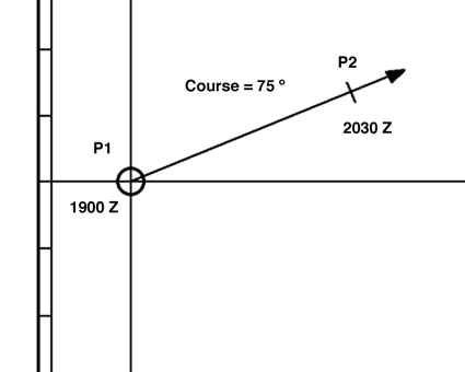
Picture 3
Picture 3 shows an example of the dead reckoning navigation. Position P1 is starting or any another precisely fixed submarine position. From the position P1 is drawn the submarine course, in this example the course is 75 degrees. The submarine speed is 10 knots (by the submarine log). It means that in one hour the submarine passed distance of 10 nautical miles. In one and half-hours the submarine passed 15 nautical miles. In this example the first position is fixed at 1900 Z. At 2030 Z the submarine position is 15 nautical miles from the first position. Distance of 15 nautical miles is plotted on the submarine course; intersection of the course and little tiny line is the submarine dead reckoning position at 2030 Z (P2).
The dead reckoning navigation is based on the first precisely fixed position; a submarine's course (drawn on nautical chart), a submarine speed and passed time. The dead reckoning navigation is important for a submarine underwater navigation and for the polar navigation.
The dead reckoning position is fixed by means of compass and log. Externals (negative) factors are sea currents. The sea currents are streams (because of tides, mainly in coastal waters) and permanent (ocean) currents. Currents and streams together make flows. Their direction and rate (speed) define the sea currents.
In some channels and coastal waters the streams rate is from 4 to 5 knots, somewhere up to 10 knots and more. If the sea current direction is exactly opposite to a submarine course, the submarine speed will be lower. If the sea current direction is same as a submarine course, the submarine speed will be higher. All other current directions get a submarine away from her course. Graphically solution of underwater navigation in the area of permanent current is based on adding of vectors.
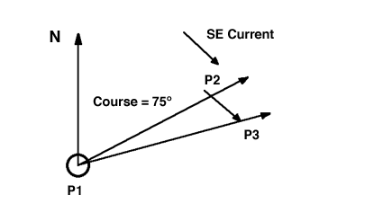
Picture 4
Picture 4 shows situation when a submarine navigates underwater in area of permanent current. Position P1 is precisely fixed the submarine position. The submarine course (75 degrees) is drawn from the position P1. Firstly, dead reckoning position (P2) must be fixed, without influence of the sea current. Position P2 is fixed by means of the submarine speed and passed time. Line between P1 and P2 is the first vector. The sea current direction (SE) and the current rate define second vector. Position P2 is moved in direction of the second vector (sea current). At the end of the second vector is position P3. Position P3 is dead reckoning position, given by influence of the submarine course and speed, passed time and the sea current. Vector P1-P3 is result of adding of vector P1-P2 and vector P2-P3.
If a sea current change its direction and rate, it is necessary to fix a submarine (dead reckoning) position at any change of the current direction and rate. Fixing of dead reckoning position is delicate work, which requires a lot of practice in navigation. Even then, the dead reckoning position can be incorrect. The dead reckoning position is just approximate. Reliability of dead reckoning navigation depends on determining of (as precisely as possible):
- compass deviation (during underwater navigation)
- coefficient of accuracy of a submarine log
- direction and rate of underwater sea current(s)
- grading of underwater overgrown condition of a submarine hull
Sources of errors in dead reckoning navigation are incorrectly steering, imperfection of navigational instruments (compass, log…) and external influence (sea currents). During the underwater navigation it is necessary to keep ordered course and speed as correct as possible.
5. Omega navigation system
Omega navigation system is phased hyperbolic radio navigation system of the biggest range. The Omega system covers the whole Earth. The system uses Very Low Frequencies (VLF), from 10 kHz to 14 kHz. The system is in experimental work from 1960. From 1972 to 1975 a network of transmitters is built (8 transmitters positioned all around the Word). The Omega system consisted of land transmitters and Omega receivers on ships and submarines.Because of used frequencies (10 kHz to 14 kHz) submarines are able to use the system even when they are submerged, up to depth of 10 to 30 metres.
Working principles of the Omega system:
The land transmitters transmit signal on three frequencies, 10.2 kHz, 13.6 kHz and 11.33 kHz. Frequency 10.2 kHz is main frequency. A submarine Omega receiver measures phase difference of signals (frequency 10.2 kHz) which are transmitted by two Omegas transmitters. If the submarine position is already known within limits of plus/minus 4 nautical miles, it is enough to fix the submarine position. If the position is not already known within limits of plus/minus 4 nautical miles, it is necessary that the Omega receiver receive signals of 13.6 kHz and 11.33 kHz. Those signals are intended for identification of lane. The first Omega receivers display marks of the hyperbolas. There is also Omega plotting charts, with drawn hyperbolas. The Omega plotting charts are intended just for fixing of a ship (a submarine) position by means of the Omega system. The position is determined by intersection of two hyperbolas, which marks are displayed by the Omega receiver. It means that in the Omega system lines of position are hyperbolas. On the Omega plotting charts theoretical spreading of electromagnetic waves draws the hyperbolas. Because of that there are also Omega propagation correction tables for 10.2 kHz, which partly solve problem of hyperbolas deformation. The modern Omega receivers the phase difference of signals transmitted by two or more pairs of the Omega transmitters transform directly in geographical coordinates.
Accuracy of the Omega navigation system decreases by distance between the Omega transmitter(s) and a submarine. At the Omega system signal final range errors are 1.5 to 2 nautical miles during the day, 2 to 3 nautical miles during the night and more than 3 nautical miles during the sunrise and the sundown.
6. Hydro-acoustical navigation system
Hydro-acoustical devices help a submarine to "see" environment around itself. The hydro-acoustical devices are sonar (active and passive), echo sounder, ultrasonic log (Doppler Sonar Navigator) etc. There are ultrasonic transmitters positioned on the ocean floor. Positions of the transmitters are drawn on special (naval) charts. Each transmitter has its own signal characteristic.A submarine fixes azimuth and distance of particular transmitters by means of its sonar. That way the submarine fixes its position. Of course, one particular navy has the underwater transmitters just for its submarines and just submarines of that particular navy know positions and types of the transmitters. A submarine also uses the hydro-acoustical navigation during navigation in polar area, under ice cover.
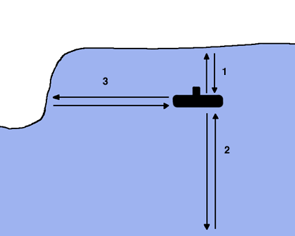
Picture 5
Picture 5 shows example of polar navigation. By means of special echo sounder a submarine simultaneously measures sea depth under its keel (signal 2) and distance between the submarine and ice cover (signal 1). By means of its sonar (in active mode) the submarine measure azimuth and distance of barrier (signal 3) which stay on the submarine course.
7. Inertial navigation system
Inertial Navigation System (INS) is passive and autonomously navigational system, which is based on inertial and gyroscope principles. The INS determines dead reckoning position by double integration of measured accelerations (of a submarine).The INS was used for the first time in the German rockets V2 in 1944. For the underwater navigation (for the first time), the INS was used on the American nuclear submarine USS Nautilus when the submarine navigated over the North Pole, under ice cover, in 1958. The INS consists of stabilized platform, accelerometers, integrators and computer. There is also a unit for elimination of accelerations registered by accelerometers, which are not included in real movements of a submarine. Stabilized platform insures precisely horizontal position and correct orientation of accelerometers, by means of gyroscopes.
Accelerometer is an instrument for measuring acceleration. The acceleration is a change of velocity. The two accelerometers are enough for a surface ship, i.e. an object that is moving in two dimensions. A submarine is moving in all three dimensions and because of that for the underwater navigation the three accelerometers are needed, two accelerometers are directed towards axis North-South and axis East-West and one is directed towards the Earth midpoint. Accelerometers determine acceleration of an object in particular direction, which is named measuring axis of accelerometer. Inside of an accelerometer is positioned a sensor mass (i.e. measuring sensor). Mainly, the sensor mass is plunged into a liquid, all together are inside of an accelerometer's cylinder.
Any change of velocity (acceleration) of a submarine makes change of position of the measuring sensor inside of accelerometer. The change of the measuring sensor position is transformed into electrical voltage and sent to the integrators.
Integrator is an instrument for performing numerical integration. In the INS integrators integrated a submarine acceleration (measured by the accelerometers) and get the submarine true velocity. By integration of the velocity the integrators get the submarine travelled distance. All data (information) are entered into computer: starting or the last precisely fixed position, correction of gyroscope axis deviation and (after the second integration) travelled distances in axis North-South, axis East-West and axis which is directed in direction of the Earth midpoint. The travelled distances are differences of geographical coordinates (latitude and longitude).
By means of the all data the computer get geographical position. Errors in the INS increase by time and not by travelled distance. Because of that, the INS is not fully autonomous during longer period of time. The INS requires control and correction by some other navigational system, as hyperbolic navigational system, satellite navigational system etc.
Good point of the INS is that the INS not required any external information. Because the INS not transmits any energy and not receives any external signals, the system keeps its presence in secret. The INS not requires any other navigational unit, as gyrocompass, log etc. The INS independently gets current velocity, a ship (a submarine) true course and travelled distance.
Once again, a submarine need the INS equipped with three accelerometers. One accelerometer is directed in direction of axis North-South, one accelerometer is directed in direction of axis East-West and one accelerometer is directed in direction of the Earth midpoint. The reason why a submarine needs three accelerometers is because the submarine navigates in all three dimensions, unlike a surface ship, which navigate in just two dimensions. And because of that a surface ship need the INS equipped with two accelerometers.

Picture 6
Picture 6 shows example of part of an INS equipped with just two accelerometers because of more easily understanding. The accelerometers are positioned on stabilized platform, which is always in horizontal position. The first accelerometer (A1) is directed in direction of axis North-South and measure acceleration in this axis. The measured accelerations (a1) get to the first integrator (INT). Result of the first integration is true velocity (v1) in direction of axis North-South. The true velocity (v1) goes to the second integrator. Result of the second integration is travelled distance (s1) in direction of axis North-South, i.e. difference of geographical latitude.
The second accelerometer (A2) is directed in direction of axis East-West and measure acceleration in this axis. Measured acceleration (a2) gets to the first integrator. Result of the first integration is true velocity (v2) in direction of axis East-West.
The true velocity (v2) goes to the second integrator. Result of the second integration is travelled distance (s2) in direction of axis East-West, i.e. difference of geographical longitude. The travelled distances (i.e. differences of geographical latitude and longitude) get to the computer (not shown on picture 6). After the computer add the travelled distances (s1 and s2) and starting (precisely fixed) position, the computer gets current position.
In this chapter the INS is explained in a simplified manner. In reality the INS is very sophisticated. As a matter of fact, nothing is simple on a submarine.
8. Conclusion
There are many preparations for efficacious navigation. In this chapter will be explained the few ones. After a submarine get out of a shipyard the submarine first goes to test-voyage. Any submarine has its own manoeuvring elements as velocity, maximum range of navigation, inertia, diameter and period of a submarine turning, angle-velocity of a course change, decreasing of velocity when a submarine change its course etc.There are specially equipped submarine testing sites for measuring velocity of a submarine, particularly during the submarine surface navigation, navigation on periscope depth and finally full underwater navigation. Underwater cables (at the bottom of the sea) are placed vertical to direction of a submarine motion. The cables are parallel one to another and positioned on the precisely fixed distances. Special indicators, positioned on land, show maximum induction of electromagnetic energy in a particular cable, when a submarine passes over it. This way it is known how much time the submarine needs to travel from one cable to another, i.e. the submarine velocity.
The submarine testing sites could be equipped with hydro-acoustical devices (active and/or passive). The hydro-acoustical devices are positioned underwater, anchored on some depth. By means of a submarine's sonar (in active and/or passive mode) and the anchored hydro-acoustical devices it is easy to fix the submarine current positions and finally to fix the submarine underwater velocity.
By the manners mentioned above, a submarine velocity is determined with specific number of the submarine's propeller revolution. The velocity is determined for 1/4, 1/2, 3/4 power of the submarine's engine and for maximum permanent velocity of the submarine.
Before any navigation a navigator must research navigational charts and navigational manuals which are concerned for the navigational area. In the manuals there are information about sea currents, sea tides etc. Depths of the sea (marked with isobaths) are especially important.
Finally, during the navigation, any new information about sea conditions in the navigational area (especially about sea currents) and about the submarine navigational characteristics under the influence of the sea conditions must be recorded because of further researching.
A submarine's position must be known at all times during the navigation of the submarine. The first reason is safety of the submarine. Also, just the submarine's precisely fixed position ensures that the submarine is ready for combat at any time. There is currently no perfect and absolutely accurately navigational system. Accuracy of the any navigational system must be checked by another navigational system(s).
This article was published on 16 Aug 2005.