

The loss of U 325, U 400 and U 1021
Re-assessment of German U-boat losses in World War II
by Dr. Axel Niestlé
(All Times are Central European Time (GMT + 1))
14 February 2004
amended on 17 October 2006 and 11 May 2007
Note: This report and the conclusions therein are protected by copyright and/or other intellectual property laws, and any unauthorized use of the material may violate such laws. No part of this report may be reproduced or transmitted in any form or by any means, electronic or mechanical, including photocopying, recording, or by any information storage and retrieval system, without permission in writing from the author.
During the period 1990 to 2001 three wartime wrecks of German WWII type VIIC U-boats have been discovered by the private divers L F Welch and Innes McCartney off the Cornish Coast in the following wreck positions:
| No 1: | 50°39,8 N / 05°05 W |
| No 2: | 50°33,3 N / 05°11,6 W |
| No 3: | 50°32,4 N / 05°23,2 W |
According to the official list on German U-boat losses during World War II, published jointly by the British Admiralty and the Cominch US Navy in 1946, no German U-boats were recorded as wartime losses in these waters. A thorough examination of all German U-boat losses revealed that until the end of November 1944 all boats recorded as lost after having been directed to operate off the Cornish coast are known sunk in other areas. After November 1944 several more type VIIC boats received explicit orders to operate in the general area off the Cornish coast between Lands End and Milford Haven. Of these, U 400, U 1021 and U 325 did not return.
U 400 (Kapitänleutnant Horst Creutz) left Kristiansand South on 18 November 1944 for its first war patrol. There is no record of any signals having been received from U 400 after the boat had been released at 2030 on the same day by UJ 1101 at point »Krista« (58°01,3n/06°40,5e). This procedure was not unusual for that time of the U-boat campaign when boats travelled completely submerged and avoided to use radio signals for fear of being monitored and located by shore or ship-borne direction finding systems. On 28 November 1944 U-boat Command advised the boat to proceed to naval grid square AM 70 as a steering area. No passage report on passing to the west of Ireland was requested. On 4 December 1944 the boat was ordered to patrol along the coastal waterway North East of Lands End. Based on the average consumption of fuel and provisions U-boat Command reckoned with its return to base on or about 30 December 1944. In order to get urgently needed information about the operational situation in the Bristol Channel and to evaluate the technical features of the prototype 3.7 cm AA-gun Type 43 fitted to U 400, the boat was ordered repeatedly in the following days to send a report on experiences. On 19 January 1945 it was routinely allocated to Stavanger as the port of destination at the end of its patrol. When U 400 failed to return to port it was posted as missing at the end of January 1945 with effect from 3 January 1945. No information about the cause of its loss was then available to U-boat Command.
After the war the Allied A/S Assessment Committee attributed the loss of U 400 to a depth charge attack by the frigate HMS Nyasaland at 2315 on the 17 December 1944 in the position 51°16N/08°05W. The frigate was part of Escort Group 18 to escort the outbound passenger ship Rimutaka, carrying HRHs the Duke and Duchess of Gloucester to Australia. At 2315 Nyasaland obtained a strong ASDIC contact at 2.500 yards and at 2338 attacked with a pattern of ten depth charges. At 2358 a Hedgehog attack was carried out, resulting in at least seven explosions nine seconds after the projectiles had hit the water. This was followed quickly by a violent underwater explosion. After the attack oil came to the surface. Based on the reported details, the attack was graded as „B – probably sunk“ by the Committee. The post-war identification of the target as U 400 is, however, open to question. The attribution was apparently based on the wrong assumption, derived from Ultra signal intelligence, that U 400 should have been the only U-boat to operate in this area at the time. From U-boat Commands daily plot it is obvious that U 400 should have passed the position of attack already about a week earlier on its way to its assigned patrol area. Although the destruction of a U-boat in the action appears very likely, the probability for the presence of U 400 is only remote. Recent research by the author now indicates that HMS Nyasaland very probably sank U 772 on this date.
U 1021 (Oberleutnant zur See William Holpert) left Bergen on 20 February 1945 for its first war patrol in British inshore waters following an abortive attempt in mid-February due to schnorkel failure. There is no record of any signals having been received from U 1021 after the boat had left port. On 1 March 1945 U-boat Command advised the boat to proceed towards the southern edge of naval grid square AM 70 as a steering area. On 8 March 1945 U 1021 was finally allocated to the operational area along the coastal convoy route on both sides of Lands End from naval grid square BF 2251 (off Pentire Head) to BF 2371 (Bigbury Bay). The focus of operations was to be in square BF 2198, which is the area between Cape Cornwall/Pendeen Head and Cape Cornwall Bank. Although U 1021 failed to answer a request on 10 March 1945 to sent its routine passage report when passing to the west of Ireland on its way South, U-boat Command nevertheless believed the boat to have arrived in its operational area. On 14 April 1945, assuming U 1021 to have by then already commenced its return to base, it was routinely allocated to Trondheim as the port of destination. When the boat failed to return to port, it was posted as missing on 5 May 1945 with effect from the same day. No information about the cause of its loss was then available to U-boat Command.
After the war the Allied A/S Assessment Committee attributed the loss of U 1021 to a series of depth charge attacks by the frigates HMS Rupert and HMS Conn at 1810 on the 30 March 1945 in the position 58°19N/05°31W. Apart from the fact that the attack took place far away from the likely outbound route of U 1021 and its assigned operational area, the U-boat sunk on this occasion was positively identified by the author as U 965 in December 1991 from items recovered and reported in the attack report. Therefore, the location and the circumstances for the loss of U 1021 are again unexplained. When information about the discovery of the first U-boat wreck off the Cornish coast (actually wreck No 2 of the list above) appeared in summer 1990, the Naval Historical Branch (NHB) of the British Ministry of Defence had speculated that the wreck could be U 1021.
U 325 (Oberleutnant zur See Erwin Dohrn) left Trondheim on 20 March 1945 for its second war patrol in British inshore waters. On 29 March 1945 U-boat Command ordered the boat to occupy naval grid square BE 3531 with an operational radius of 30 nautical miles. This order was however cancelled the next day and on 31 March 1945 the boat was advised to continue its southward passage west of Ireland as far as the latitude of naval grid square BE 31. On 7 April 1945 U 325 sent the routine passage report from naval grid square AL 61, indicating that the boat had hauled far to the west on its outbound route. Three days later U-boat Command ordered U 325 to operate on the coastal convoy route on both sides of Lands End from Bull Point to Lizard Head. At the time of the cessation of hostilities U-boat Command considered U 325 still as operational. When U 325 thereafter failed to enter base or to show up at one of the Allied assembly points, its loss became apparent. No information about the cause of its loss was then available to U-boat Command.
After the war the Allied A/S Assessment Committee attributed the loss of U 325 to a series of depth charge attacks by the destroyers HMS Hesperus and HMS Havelock on 30 April 1945 in position 53°42N/04°53W. Following a radio report from Sunderland H/201 RAF about a diving U-boat in position 53°42n/04°55w at 0810, the two destroyers closed the scene of sighting and finally obtained a contact classified as a bottomed U-boat from Echo Sounder trace. A total of six Hedgehog and two depth charge attacks with five charges each were directed against the target between 1516 and 1759. Following the third attack air bubbles, oil and various items of debris broke surface. Based on this evidence the attack was assessed as “A – U-boat known sunk”. When fresh information on U 325’s actual operational area became known from German records during the 1950’s, the NHB revised the original assessment. Now allocating the destruction of U 242 to the action, U 325 was then considered as lost to unknown cause in the absence of a plausible explanation for its loss.
With the loss of all three boats directed to the area off the Cornish coast being unexplained, it appears reasonable to assume that they are identical with the newly discovered wrecks. Based on the results presented above it is evident that all three boats can be expected to have reached their assigned operational area off the Cornish coast. From the almost complete absence of U-boat activity during the various theoretical periods of stay in the operational area it seems probable that all three boats were lost soon after their arrival. Examination of visible physical damage on the wrecks leads to the conclusion that mining seems to be the most plausible explanation for their loss.
The Royal Navy had in fact laid out various mine fields in the general area between 1941 and 1944. At the end of October 1944 intercepted Ultra intelligence revealed the German intention for a probable renewal of U-Boat operations between Lands End and the Bristol Channel from Norwegian bases. On 29 October 1944 U-boat Command radioed a situation report for the Bristol Channel area to all boats at sea, which was to be kept permanently by the boats in the situation report file. According to para. 1 of it, the limits of the British declared mine area were known as follows: 52.10 n / 06.15 w and 52.00n / 07.35 w through 51.35 n / 06.15 w and 51.00 n / 07.15 w to 51.01 n / 04.31 w and 50.33 n/ 05.01 w. Noting that the area was last mentioned by British authorities at the beginning of 1943, the boats were informed that otherwise no evidence was known that mines are still there. It was assumed that the mine fields were no longer renewed so that there was no longer any danger to the boats. In para. 2 of the situation report, the convoy route under the English coast was given as: 51.05 n / 04.43 w as far as 51.02 n / 04.32 w to 50.33 n / 05.02 w as far as 50.35 n / 05.15 w. Boats should expect daily some three convoys for Channel ports from and to the Bristol Channel passing Lands End at night, also war and merchant vessels sailing singly. On 18 November 1944 para. 1 of the Bristol Channel situation report was amended in the way, that the presence of minefields inside the declared area was to be assumed and the boats were reminded to pay attention to limits of the mined area. However, U-boat Command gave assurance that shipping routes radioed in para. 2 were mine-free. Four days later U 680, which had left Bergen on 13 November 1944 for a patrol in British coastal waters, was directed as the first boat to occupy the area given in para. 2 of the Bristol Channel situation report as attacking area. However, following a promising situation report from the English Channel area by U 978, U 680 was redirected to the latter area on 2 December 1944. Only two days latter U 400 received the order to patrol off the Cornish coast as a replacement for U 680.
Through Ultra decrypts the British Admiralty was well and timely informed about all of the above-mentioned German situation reports and operational intentions. According to the Naval Staff History of British Mining Operations 1939-1945 Vol. I, the Admiralty issued a policy signal to CinC Western Approaches on 15 November 1944 stating that "further consideration has been given to the relative importance of anti-U-boat minefields in the NW and SW Approaches. Routing of ocean convoys south of Ireland not only renders this the more attractive area but U-boats' course of action can to some extent be anticipated. In the NW Approaches, mine-laying operations must follow rather than anticipate U-boat activities. […] Consider therefore as a matter of policy that mine-laying operations should be concentrated in the SW Approaches”. In pursuance of their stated policy and to meet the expected concentration of U-boats in the SW Approaches, the Admiralty ordered, by signal on 25 November 1944, that the minelayer HMS Apollo should lay three lines of deep mines off Trevose Head, before cleaning boilers and making good defects at Plymouth. The operation “HW” was to be conducted by C in C, Plymouth, and it was forecast that the minelayer HMS Plover would be available, at the beginning of December, to continue these fields along the swept channel between Trevose Head and Hartland point in operation “HY”. Between 29 November 1944 and 3 January 1945, the two minelayers laid over 1,200 Mk XVII moored mines in 11 ‘deep fields' across the coastal convoy route along the north coast of Cornwall. Moored mines were used because ground mines sensitive enough to catch slow-moving U-boats would also have posed a threat to Allied surface ships. It will be noted that these mines were placed exactly within the area U-boat Command had explicitly declared mine-free in its amendment to the Bristol Channel situation report on 18 November 1944. Being aware of this advice, the British Admiralty set a well-placed mine-trap.
Comparison of the exact geographical coordinates for the individual mine fields with the nautical positions of the three U-boat wrecks revealed that each of the wreck positions are a nearly a perfect match with one of the above mentioned minefields:
Wreck No 1 rests in the southern half of field “HY A1”, laid by Plover on 12 December 1944. Consisting of 100 Mk XVII (39)/XVII units, it spread along a line extending for 3.3 miles in direction 171° from position 50°42.5N, 05°05.4W at a depth of 70 feet. Two surface failures were reported during laying.
Wreck No 2 is situated in the southern half of field “HW A3”, laid by Apollo between 0131 and 0156 on 3 December 1944. Consisting of 156 Mk XVII (39)/XVII units, it spread along a line extending for five miles in direction 182.5° from position 50°36.7N, 05°11.1W at a depth of 70 feet. One possible failure was observed during laying.
Wreck No 3 lays on the southern end of field “HW A1”, laid by Apollo between 0131 and 0156 on 29 November 1944. Consisting of 156 Mk XVII (39)/XVII units, it spread along a line extending for five miles in direction 179° from position 50°34.5N, 05°23.0W at a depth of 70 feet.
From the evidence reported above it is beyond all doubt that all three U-boat were in fact lost to secretly laid allied minefields, which had remained unknown to German U-boat Command for the duration of the war.
Apart from the presence of the three wrecks, no direct information on their identity was found. However, detailed underwater examination of the wrecks by the diver Innes McCartney revealed numerous design and equipment features. Comparison of these individual features with available information on the contemporary outfit of the three boats in question by the author eventually allowed to conclude on the most likely identity of the three wrecks. Accordingly, wreck No 1 should be U 400, wreck No 2 should be U 1021 and wreck No 3 in all likelihood should be U 325. The assessment is mainly based on the following conclusions:
Wreck No 1 is fitted with the old Type 1 folding schnorkel installation with half-height pressure flange connection to the diesel air intake tube along the port side of the conning-tower casing in combination with a ring-float schnorkel valve with Wesch-type anti-radar coating on the circular stem tube between the exhaust outlet and the ring-float head. No anti-radar coating is found on the drum-shaped ring-float head. The circular foundation plate for a deck gun originally installed on type VIIC boats is clearly in place in front of the conning-tower, forward to the rectangular hatch covering the former ready-for-use ammunition space. In addition, the gun mount of the 3.7 cm AA gun now lying on top of the wreck closely resembles the late-war Type LM43U gun mount. U 400 was fitted with one of the first such mounts for frontline testing. While U 1021 is known to have been fitted with a ball-float schnorkel head, U 325 is recorded to have carried the Jaumann-type anti-radar coating on its ring-float type schnorkel head. In addition, U 325 was never fitted with the deck gun foundation plate. Based on this evidence, it is concluded that the identity of the wreck No 1 should be that of U 400. According U-boat Command’s daily plot, U 400 was expected to arrive in its operational area on or shortly after 14 December 1944. Thus it is entirely plausible that U 400 met its end only days after laying of the new A/S minefield.
Wreck No 2 is fitted with the old Type 1 schnorkel installation with ball-float schnorkel valve, Wesch-type anti-radar coating on the schnorkel head and four pressure-proof dinghy containers on the forward deck. Except U 1021 none of the other two boats in question carried this combination of features on its final patrol. On the basis of the average speed of advance then attained by type VIIC schnorkel boats, U 1021 is expected to have arrived in its operational area on or about 10 March 1945. That appears to coincide with the sighting of a suspected periscope on the afternoon of 10 March 1945 by the minesweeping trawlers HMS Concertator and HMS Lorraine in position 50°36’N, 05°15’W. The trawlers carried out an attack, during which they expended their full outfit of eight depth charges, without result. On the afternoon of 14 March 1945 the British steamer Rolfsborg, a straggler from convoy TBC 95, heard a heavy explosion when in 294° Trevose Head 4 miles, which converts to approximately 50°34’N, 05°07’W, and observed patches of oil. At the time of the incident there were no other surface vessels in the area. In the light of this evidence it is possible that U 1021 was lost on this occasion due to mining.
Wreck No 3 is badly corroded but none of the features found on it opposes to the outfit of U 325 to be expected on its last patrol. From the fact that U 325 passed a transit report from the area west of Ireland and the absence of any promising A/S attacks along its expected route or in its assigned operational area, it is most likely that U 325 arrived off the Cornish coast. U 325 is expected to have arrived in its assigned operational area on or about 17 April 1945. For reason of completeness it should be mentioned that in the time-span between mid-April 1945 and VE-day the following attacks by aircraft and escort ships took place near the wreck position:
| Time/date | Unit | Position | Weapon/grade | Target/result | |
| 1859/23 | Cat P21/VPB 63 USN | 50°24’N / 05°25’W | D/C | PH | non-sub |
| 1910/23 | HMS Ascension & HMS Benbecula | 50°26’N / 05°25’W | D/C | PJ | non-sub |
| 2030/27 | Sunderland F/228RAF | 50°12’N / 05°47’W | D/C | PH | non-sub |
None of these attacks produced conclusive evidence for the presence of a U-boat or any damage inflicted. The first two attacks took place after U 1023 had torpedoed the British SS Riverton at 1535/23 and were later assessed as being directed against non-sub contacts. Although Sunderland F/228 reportedly attacked a possible schnorkel, circumstances point to a meteorological phenomenon (willywaw) being targeted. After passing over the spot the aircraft became unmanageable and crashed into the sea, killing seven of its crew.
Based on the foregoing information it is proposed to amend the loss of the above mentioned U-boats in the following way:
U 400 sunk about mid-December 1944 on the British minefield »HY A1« in position 50°39,9’n / 05°05’w.
U 325 sunk during the second half of April 1945 on the British minefield »HW A1« in position 50°31,4’n / 05°22,8’w
U 1021 sunk probably on 14 March 1945 on the British minefield »HW A3« in position 50°33,3’n /
05°11,6’w.Dr. Axel Niestlé
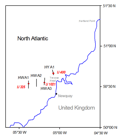
Map 1: Location of U-boat wrecks and mine barrages off Cornwall
Re-assessment of these fates since article publication
See the following PDF file for more details on further research into these wrecks.
Niestlé, Axel (2010). The ‘Atlas’ Survey Zone: Deep-sea Archaeology & U-boat Loss Reassessments, Oddyssey Marine Exploration
This article was published on 4 Jul 2007.